One of my favorite walks when I want to get outside but not into the woods is the 2.5-mile loop around Mirror Lake. The path is paved and well maintained, making it a great option for poor weather days and mud season. I've walked this loop dozens of times since moving to the Adirondacks, but my relationship with Mirror Lake has changed dramatically since working for the Ausable River Association (AsRA). Now, when I walk around the lake, I see the important work AsRA and our partners are doing to protect it, now and into the future.

Walking path around Mirror Lake, with landmarks noted.
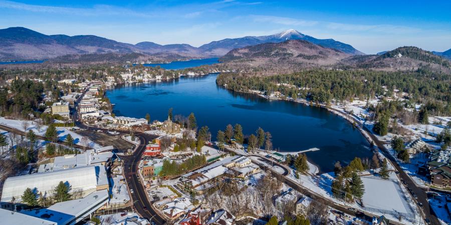
My walks around Mirror Lake usually begin at the north end of the lake, at the on-street parking near the Lake Placid public boat launch. From here, you can see both Mirror Lake and Lake Placid (the lake—which some lakeshore residents call Placid Lake, to distinguish it from the village). While the proximity of these two lakes may suggest they are linked, neither flows into the other.
Making my way clockwise around the lake, I soon pass the house on Mirror Lake Dr. where we and our partners at the Adirondack Watershed Institute park to sample the water in Mirror Lake. A house I never looked at, once upon a time, now sparks memories of sunny paddles and long, slushy trudges across the lake to monitor its water quality every other week, year-round. Very few lakes are monitored this frequently and consistently, making the Mirror Lake data set an important record.

That’s me with an ice auger, drilling a hole in the ice to access the water underneath to sample it. In the foreground is the Mirror Lake monitoring buoy.
It was our monitoring that first revealed the salt contamination of this beloved lake. This discovery led both the Village of Lake Placid and the Town of North Elba to reduce their winter salt use, an effort I've also had the opportunity to help with. Walking this path in winter, I see evidence of their efforts in the new live-edge plow that passes by me and the well swept, less salted path I walk on. My walks give me time to think about the work still left to do to reduce salt in Mirror Lake. While we have seen a reduction in the lake's salt levels, its current salt levels are still much higher than they should be and continue to impact water quality.
Views of the lake along its eastern side are mostly blocked by houses. The best way to take in the views of both the lake and the mountains from this side is to hike up Cobble Hill, whose trailhead I pass near Northwood School. Right near the trailhead, though barely visible, is the inlet to Mirror Lake. Most of the water entering the lake - aside from rain and runoff - comes from Echo Lake, via this small stream that I cross over in this section of the loop walk.
Nearing the turn around the southern portion of the lake, I pass the boathouse and open field that hold our weather stations and temperature monitoring equipment. The data gathered from these stations is shared on our website. The people who seem to rely on it most are IronMan athletes. How do we know? Web traffic to our weather station site spikes in the weeks leading up to the event, as athletes train in the lake and prepare for the big day. During this season, we know almost immediately if any of the weather sensors go offline, thanks to prompt emails and calls from athletes checking the site.

AsRA staff performing routine maintenance on one of our weather stations.
At the hand boat launch at the south end of the lake, I come across the first of four informational signs AsRA and partners installed in 2022. Like this essay, the signs aim to give people an insight into the work taking place in and around the lake. Each colorful and accessible sign focuses on one of four key topics: Mirror Lake’s Food Web, Mirror Lake’s Water Quality, Mirror Lake in a Changing World, and Landscape Connections.
A few steps later, I find myself at the public beach. At its south end is the outlet of Mirror Lake. Unlike the inlet, a small section of this stream is visible before it disappears into an underground pipe. From here, the water flows into the Chubb River, then into the West Branch Ausable River.
Just beyond the beach, I enter Main Street Lake Placid and pass the Golden Arrow Hotel, catching a glimpse of our Mirror Lake Live Camera. The camera, while sometimes a major pain when it goes offline, is one of the most beloved projects AsRA has ever undertaken. Its video feed is viewed by a quarter of a million people each year. Some check it daily to catch a glimpse of the lake, others check it to see the lake conditions before heading out for an adventure on the water, and some check it before driving to Lake Placid to see what weather awaits them. I have learned so much from working on this camera and am proud to be a part of its community.

That’s me working to get the camera back up and running in January 2023.
About halfway through downtown I come to Mid’s park. The park is not named for its central location in town or on the lake, but for Mildred "Mid" Uihlein, who played a key role in preserving the space as a public park. It has one of the best views of Mirror Lake and is a great place to see two key components of our work.
From the park, I can see our white monitoring buoy in the distance, bobbing on the water or stuck in the ice. This buoy, situated over the deepest part of the lake (18 m), measures temperature, dissolved oxygen, salt concentration, and algal productivity on an hourly basis, year-round. This data helps us understand the threats, such as stormwater runoff, facing Mirror Lake and gauge the success of programs to mitigate these threats. The buoy also marks our water quality sampling location, so you may see us out there collecting water samples.
From Mid’s park, I also see an outdoor classroom. Over the years, we’ve brought groups of all ages out onto the lake to learn about its ecosystem and the work that goes into studying it.

Participants in our Teen Stewardship Program, run in partnership with the Adirondack Mountain Club, conducting water quality monitoring on Mirror Lake.
Walking back to my car, I come to my favorite view along the lake. Near the Mirror Lake Inn, there’s a break in the trees that provides a spectacular view of the High Peaks: Mount Marcy, Mount Colden, and Algonquin. I can even see a bit of Gothics peeking out above the trees. I find this view satisfying as I have hiked to the top of Colden and plan to climb the rest. I also enjoy getting to see some of the mountains named on the 46 stone plaques in the sidewalk throughout my walk.

My favorite view along Mirror Lake.
A few minutes later, I’m back at my car, happy to have made another trip around the lake and enjoying the time spent outside.
Next time you’re looking for a walk and don’t want to venture out on the trails, consider a walk around Mirror Lake. While you’re out, think about how much we can learn by studying our environment, and about the good work AsRA is doing with your help.
Story written by Carolyn Koestner, GIS and Science Communications Fellow.
Sign-up for our e-newsletter to get weekly updates on the latest stories from the Ausable River Association.
