Winter in the Ausable River watershed brings great beauty and opportunities for recreation -– reasons our area is a destination for winter sports and tourism. For residents, it brings the same pleasures, along with the day-to-day realities of sub-zero temperatures, deep snow and ice, shoveling, snow plows, and studded tires. For our river, its East and West Branches and Main Stem, winter conceals open stream channels with varying degrees of ice and snow, while the river continues to flow and function underneath. For some residents living along the Ausable and other Adirondack rivers, river ice raises the harrowing potential of ice jams. What causes ice jams, and how are they related to winter ice and stream health?
How Does River Ice Form?
Winter ice formation in streams is commonplace in northern latitudes. As air temperatures cool, water temperatures cool. Around 39°F, stream water begins to lose density. As water continues cooling to 32°F, it rises and begins transforming into ice. In these conditions, ice forms throughout the winter and accelerates as air temperatures dip below freezing. Sun exposure, wind, rain, and the slope of the channel, velocity and depth of water, all influence how ice develops.
At least three types of ice are present in the Ausable River: surface ice, frazil ice, and anchor ice.
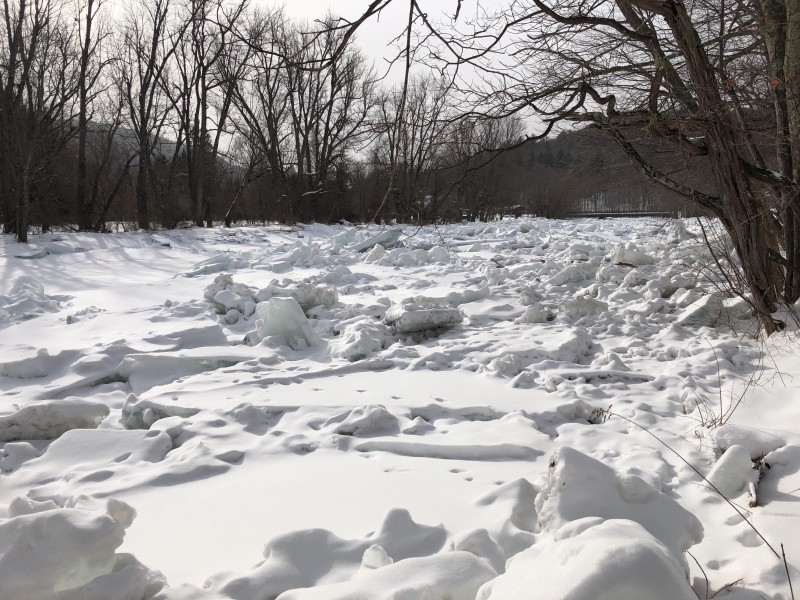
Surface ice forms most readily on low-velocity, low-slope sections of a stream. It builds out from river edges, where ice forms first along the low-velocity boundary of banks and then expands inward toward the center of the channel, sometimes covering its entire width. In extended cold periods, cooler low-density water continues to accumulate on the surface, freezing to the bottom of ice already there. As ice thickness builds, so does its insulating effect, gradually slowing the cooling of water. Slabs of surface ice in the Ausable can be 1 - 2 feet thick or more. The large intact slabs of ice that, during thaw or ice out, are deposited along the floodplain areas of the river, are surface ice.
Frazil ice is a soft ice formed by the accumulation of miniscule ice crystals and looks like snow sitting on the surface of water. It forms in more turbulent water. Air temperature must be approximately 14°F or colder, allowing the supercooling of stream water to a temperature fractionally below freezing. Frazil ice is "sticky" and will adhere to surface ice, other frazil ice, and objects above the surface, as long as the supercooling of the water continues. As frazil ice collects, it can form ice pans, sometimes referred to as pancake ice.
Anchor ice is frazil ice that moves underwater and attaches to rocks, boulders, submerged roots, or infrastructure. Anchor ice is often visible underwater in the West Branch Ausable River in turbulent or rocky sections. It is discernable from surface ice during ice-out by the fact that it often carries bits of substrate encased in it: sand, wood detritus, and cobble.
How Ice Jams Form
Stream surface ice break-up usually occurs in spring, but mid-winter thaws and rain events can also break up ice. Rainfall and melting snow produce runoff, increasing flow in the river and raising its level. When the river rises roughly 1.5 to 3 times the thickness of the ice – according to the National Weather Service (NWS) in Burlington, VT – it has the power to raise channel-bridging surface ice and break it into pieces that begin to move downstream.
Ice jams form when the amount of ice in the river exceeds the river channel's transport capacity – its ability to move materials downstream. Channel capacity is reduced by natural and human-made constrictions to stream flow; river bends, points where the river slope decreases, areas downstream of dams and upstream of bridges or other obstructions, such as remnant dams or bridge piers, that constrict or block water flow. Shallow, overwide channels with eroding banks that lack the capacity to transport sediment efficiently in warmer months can also constrict ice flow in winter. And, where access to floodplains that could store ice and floodwater is blocked by roads or other infrastructure, a river channel is forced to carry excess material downstream.
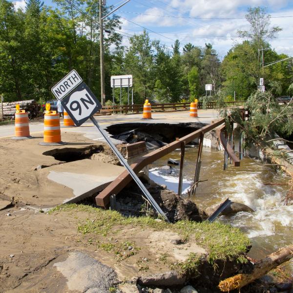
As water levels rise during a thaw and begin to break up ice and move it downstream, river channel sections with significant constriction or with channel-bridging surface ice can become barriers. In such situations, ice backs up and accumulates, creating a jam. Ice jams can fill the channel, side to side and top to bottom, temporarily dam water flow and cause upstream water levels to rise. If a jam does not break up in time, surface ice, debris, and water may move out of the channel and onto adjacent floodplains and other low-lying areas, causing flooding. Where floodplains in ice-jam prone areas are developed, this process can pose threats to infrastructure. When an ice jam does release, it can happen with little to no warning, though the NWS has developed a model to forecast break-up during thaws. Ice jam releases can create a surge of water and ice downstream that can flood lands adjacent to the river and scour the river channel, altering its bed and bank structure.
Identifying Threats and Solutions
The effects of ice formation and ice jams on a healthy, natural river with no human infrastructure nearby includes changes in stream channel structure, carving of bed and banks, and removal of, or damage to, floodplain vegetation. Such changes are neither negative nor positive, but simply shifts of form and function that will be integrated by the stream. Wildlife can be harmed by these processes, while their habitats may be damaged or improved. Fish can be frozen in ice, for example, and die or survive and swim free at thaw. Vegetation ripped from a bank can be moved to a location where it provides valuable habitat for invertebrates, fish, or other aquatic animals.
Where human communities – homes, businesses, road infrastructure – are located in the floodplain, ice jams can be significant threats to public safety. While it is easy to suggest removing vulnerable development from floodplains to save lives and the recurring costs of emergency services, the reality of doing so may not be economically feasible for the residents involved or their communities. State laws protecting Adirondack rivers disallow clearing ice from a channel by mechanical means – placing excavators and bulldozers in the river to respond to a growing ice jam. Even if this method could successfully clear and remove ice, it would reinforce some of the very problems that allow the development of ice jams in the first place: compacting and/or digging into river beds, disturbing existing channel structure, exacerbating future erosion by damaging banks, and moving cobble and materials in the channel in ways that could intensify flood patterns. When excavators do enter rivers for planned restoration work, there is often a year or more of planning and surveying, and a set of clear flagging to guide them. Short-term, emergency solutions are limited, but agencies are using machinery from roadways or stable floodplains that may help manage ice jams – as is the case on the East Branch this year.
In the end, we must look for long-term solutions that create flood resilience for our communities and reduce the damage caused by ice jams. AsRA is working with a team of river specialists and community leaders to develop comprehensive restoration plans for the Ausable system, starting with the lower half of the East Branch that runs through the Town of Jay. Several projects have been identified -- after intensive surveys and analyses of hydrology, hydraulics, geomorphology, water quality and biology -- and are moving to the design phase. Once funds are secured, projects will be permitted and implemented. Each project restores stream form and function, alleviates ice-jam formation, and creates flood resilience. It is a long-term but achievable goal that improves public safety, protects our clean water, restores stream health, and conserves habitats – all benefits for our communities, human and wild.
Sign-up for our e-newsletter to get weekly updates on the latest stories from the Ausable River Association.