In recent years, the Ausable Freshwater Center (AFC) has advanced several significant natural stream restoration projects in the Ausable River watershed (e.g. Dream Mile, Rocky Branch). Our work relies on a restoration partnership with the US Fish and Wildlife Service (FWS) and engages other project specific partners (e.g. landowners, towns, contractors, other nonprofits, and New York State agencies) as needed. As our technical expertise has increased and as we have learned more about the needs of the river, our goals have shifted from resolving isolated problems to establishing and implementing comprehensive plans for the restoration of self-sustaining form and function to Ausable River system, starting with the East and West Branch Ausable Rivers. Click here to take a virtual tour of our river resotration projects.
Banks can be stabilized, and habitat improved in pockets as opportunities, funding, or emergencies arise, but this reactive approach has its limits. Self-sustaining equilibrium for the East and West Branch Ausable Rivers and for the Ausable's Main Stem – minimized damage in storms, lower long-term costs for towns, informed engagement from landowners and the public, and fewer interventions needed by state and federal agencies – can most economically, efficiently, and effectively be achieved with a comprehensive plan that starts with the science of rivers, their hydrology, hydraulics, geomorphology, biologic, and physicochemical needs. AFC is pursuing a multi-year effort with the goal of restoring self-sustaining equilibrium and habitat diversity and we've started with the East Branch Ausable River. Click here to learn about our recent project on the East Branch in Upper Jay.
The East Branch Restoration Plan
A PLAN FOR RESTORING STREAM HEALTH
The Ausable Freshwater Center (AFC) is creating flood resilience for the Town of Jay. Our goals are to help the river break up ice jams, rebuild the lush riverside habitats that stabilize banks, and restore the oxygen-rich riffles and deep pools of the East Branch Ausable River that support native species and once made this a destination for anglers.
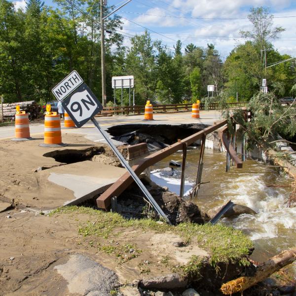
The East Branch Restoration Program is a comprehensive strategy for protecting the cool, clean waters of the lower East Branch Ausable River while creating flood resilience for the communities alongside it. The restoration program was developed in the wake of Tropical Storm Irene—the largest flood on record in the Ausable watershed, which devastated the region in 2011. In response, New York State's Office of Resilient Homes and Communities funded intensive field assessments, community conversations, and the preparation of a detailed report describing the steps toward greater flood resilience. As part of this effort, a team of experts convened by AFC, with oversight from the US Fish and Wildlife Service (USFWS), identified and developed conceptual designs for 13 stream restoration projects along the East Branch in the Town of Jay. As of 2024, two projects have been completed using a mix of local, state, and federal funds. Project Area 3 (completed in 2021) and Project Area 2 (completed in 2023) were implemented to protect public and private infrastructure and reduce the risk of ice jams in Upper Jay.
WHAT'S NEXT?
Project Area 13, below Au Sable Forks, is fully designed and engineered and AFC is seeking funds from the NYS Clean Water, Clean Air and Green Jobs Environmental Bond Act to proceed with construction in 2026 or 2027. An additional $2 million of Federal Congressional funds administered by the US Department of Agriculture – Natural Resources Conservation Service (USDA-NRCS) is moving several other projects forward. Project Area 5 to protect NYS Route 9N between Jay and Upper Jay will be fully engineered and ready for implementation in 2027. Project Area 7, above the hamlet of Jay, will be reconnected to the river, expanding wetlands and floodplains to absorb ice, flood water, and sediment before they move downstream. Additional funds from the Lake Champlain Basin Program, will allow us to implement this project in summer 2026.
And USDA-NRCS funds will support the extension of the East Branch Restoration Program into the Town of Keene, which began in 2024—providing a comprehensive plan for restoring the entire East Branch.
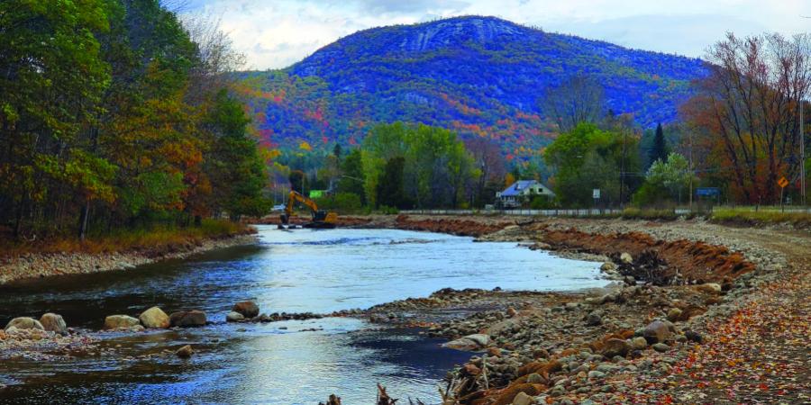
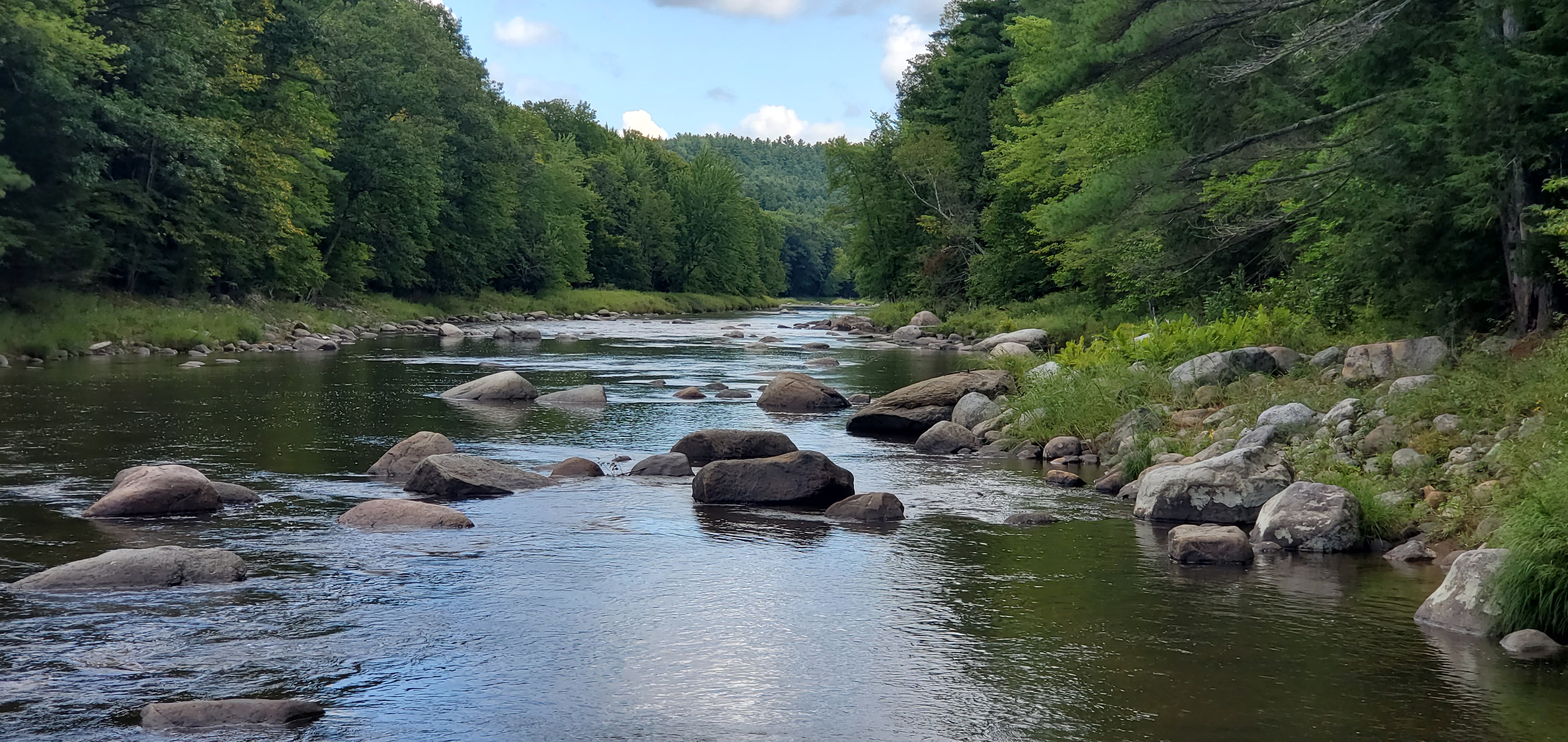
Toe wood benches like the one pictured above are among the tools used in natural stream restoration. This 30-foot-deep bench sits just above normal low flows. It is constructed of 60 to 80-foot trees, 18–24 inches in girth, with their root wads intact. Each tree is laid horizontally, angled slightly downward and into the water flow with 10–15 feet between each root crown. The roots sit at the toe of the slope, hence the name. Natural materials—river sediment, wood, and coconut fiber fabric—are layered on top of the trees. The top is seeded with native plants so that, within a few years, the bench will be indistinguishable from other healthy banks. The bench narrows the channel and plays a vital role as water rises. In a typical spring flood, water will move up onto the bench, slowing its velocity and providing protection for the road. The toe wood is resilient, easily withstanding high flows and ice, providing habitat for fish, absorbing stream energy, and slowing flood water.
THE PROBLEM
A river needs to move both water and sediment through its channel and floodplain to its outlet. That’s its job. But, in many sections of the East Branch Ausable River, the movement of sediment is out of balance as a result of historic land use pressures and a changing climate. To accommodate log drives on the river—which happened annually for decades, ending 100 years ago—it was straightened, dredged, and dammed to create the flows needed to move logs downstream. For decades thereafter, gravel was mined from the river for road maintenance. Our infrastructure, such as roads, bridges, culverts, and other utilities, puts pressure on the river and limits its ability to migrate within its floodplain.
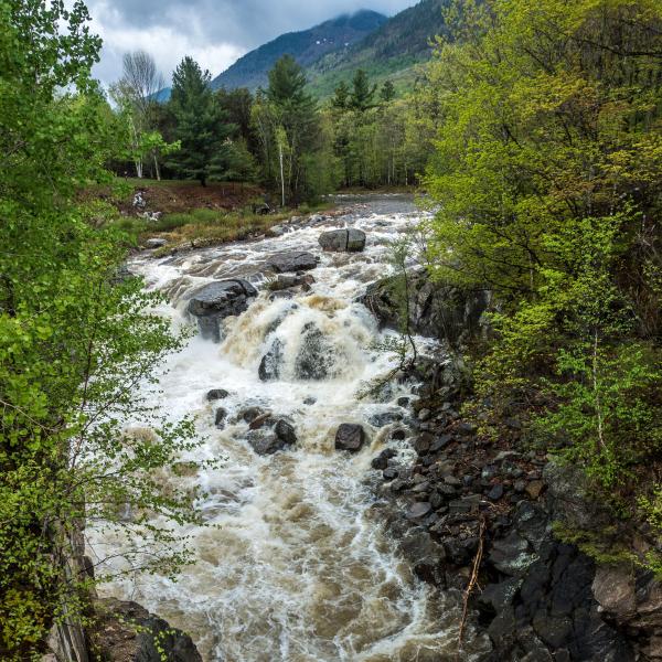
How do we know the river is out of balance? Small, shifting islands of sand, gravel, and cobble form in the middle of channels that have been widened by bank erosion. During low to moderate flows, water is forced from the middle of the channel towards its banks, where it undercuts vegetation and leads to more erosion. These failing banks put more sediment into the river, damaging the food webs and breeding cycles of native fish and threatening roads, homes, and businesses. Several of the highest priority projects identified in this restoration program address these imbalances. They focus on reaches where the channel is too wide, with too much sediment, where failing banks threaten communities and there is little to no habitat for our prized native brook trout. In a watershed with no human presence, a river has time (hundreds of years) and space (thousands of feet on each side) to repair itself. But in a system such as the East Branch Ausable River where development—roads, homes, hamlets—hugs the river and communities cannot be relocated, that time and space are not available.
THE SOLUTION
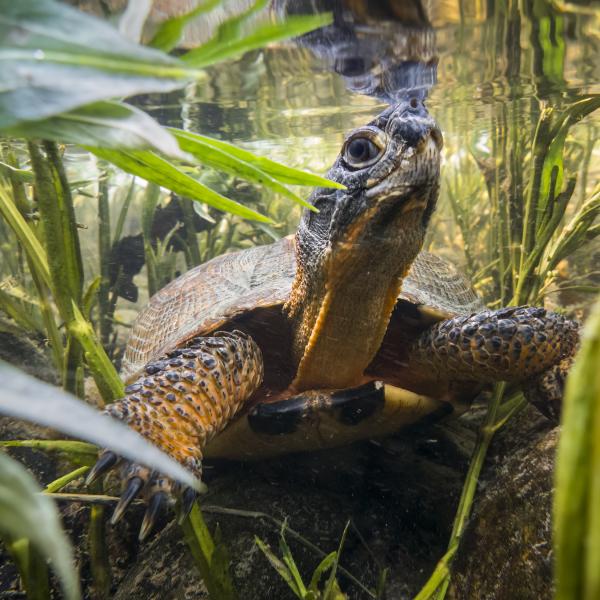
Over the last several decades, scientists and engineers have realized that the old approach to managing rivers can do more harm than good. Hardening banks with concrete walls and blasted stone, digging deeper channels, and straightening bends in a river were typical responses to erosion and floods that threatened development and infrastructure in years past. These management practices may protect one area, but they tend to shift problems downstream. They also destroy critical habitat for the native brook trout that depend on the alternating riffles (shallow, swift, oxygen-rich waters) and pools (calm, deep waters with cooler temperatures) with densely vegetated banks found in healthy rivers.
A more natural way to address historical damage in rivers is to mimic what works on resilient rivers with stable banks, since these withstand moderate flooding with little damage. Wood is used to rebuild banks in a way that stimulates food webs for brook trout. Native boulders are arranged in the channel to direct flows away from the banks, maintain the slope of the channel, and prevent the buildup of sediment that smothers life and destroys the riffle-pool structure. The river is reconnected with its floodplain in a strategic way to store flood water and ice in places that protect infrastructure and communities.
Each project is carefully designed, the result of an intensive assessment and engineering process. AFC conducts topographic and geomorphic surveys to create a detailed map of the channel and floodplain. Computer models are developed using these maps to test different design options for moving sediment and withstanding erosion while maintaining habitat features. These models also simulate flooding associated with different sized storms to ensure public safety. During this process, we meet with local communities and landowners to hear their feedback throughout the design process.
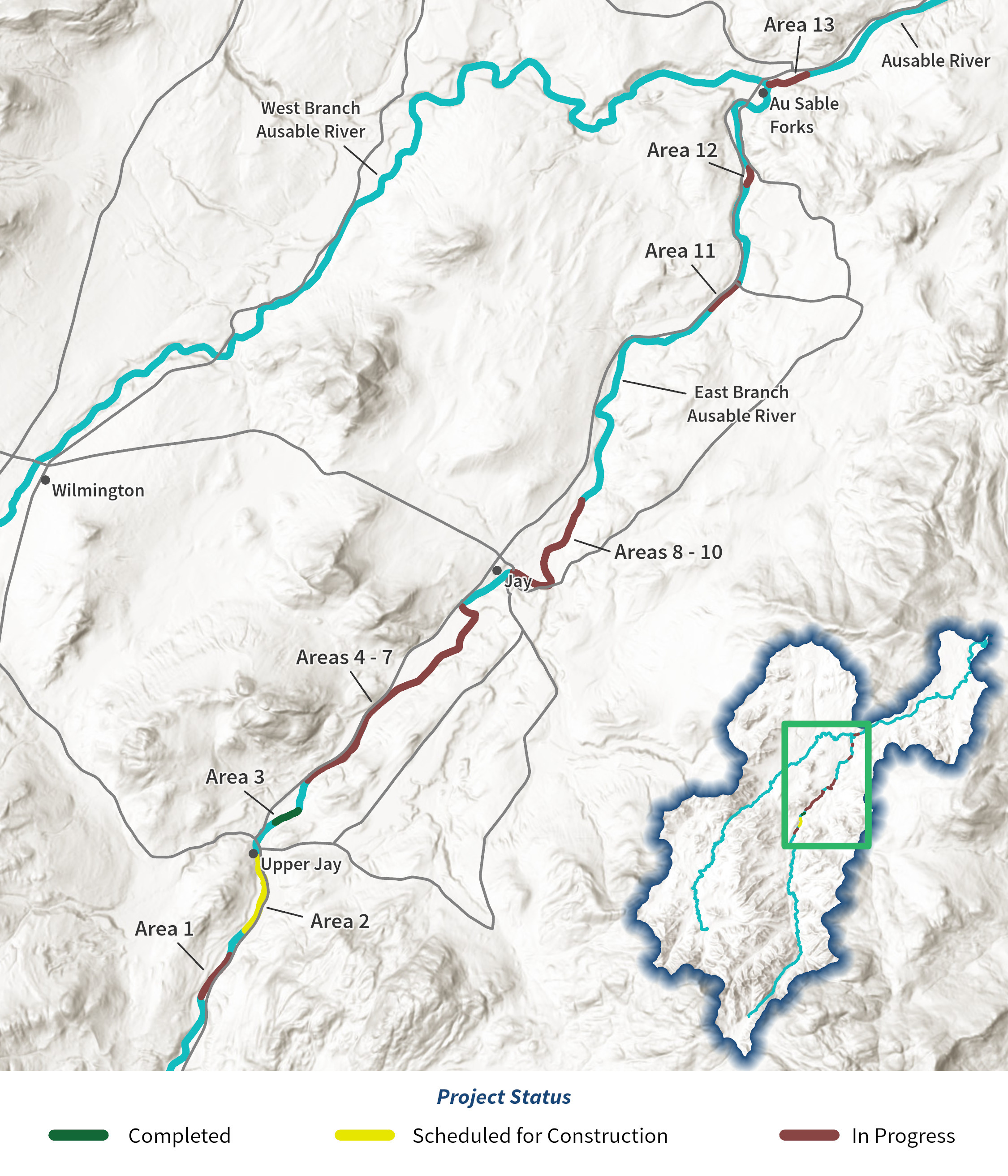
The East Branch Restoration Program identifies 13 sites in the Town of Jay in need of restoration to improve flood resilience, protect communities and infrastructure, and restore habitat for the food web that supports our native brook trout. AFC has received funds to expand the restoration program through the Town of Keene in 2025–26.
PARTNERING FOR SOLUTIONS
Since 2010, AFC has led several significant natural stream restoration projects in the Ausable River watershed. Our work relies on a restoration partnership with the USFWS and other project-specific partners—landowners, towns, contractors, other nonprofits, and New York State agencies. As our efforts have grown and we have learned more about the river’s needs, our goals have shifted from resolving isolated problems to establishing and using comprehensive plans to restore the Ausable River system, starting with the East Branch.
AFC’s approach to stream restoration rebuilds the self-sustaining capacity of the river. We work on damaged sections of the river. While rivers can heal themselves, they need significant amounts of time and space to do so. Where human infrastructure cannot be moved to allow the river to heal, we can intervene. Using only native stone, trees, and biodegradable fabric, we repair the channel and banks with careful planning and mathematical precision. The result, over time, is a beautiful flowing channel of oxygen-rich riffles and deep pools with thick stands of native trees and understory plants along the banks. It’s good for the river, for water quality, for biodiversity, and it’s the foundation for healthy, vibrant Adirondack communities. It doesn’t stop flooding, but in places where human infrastructure must exist in proximity to a river, it reduces unpredictability and allows human communities to flourish alongside natural ones.
Additional funds are needed to advance this work. Our comprehensive plans are efficient and effective tools to move multi-year projects forward. Each of these projects builds resilience for communities, provides protection for infrastructure, and restores our fishery. Our planning efforts can also serve as a model for the rest of the Ausable watershed and neighboring systems, including the Boquet, the Little Ausable, the Chazy, and beyond.
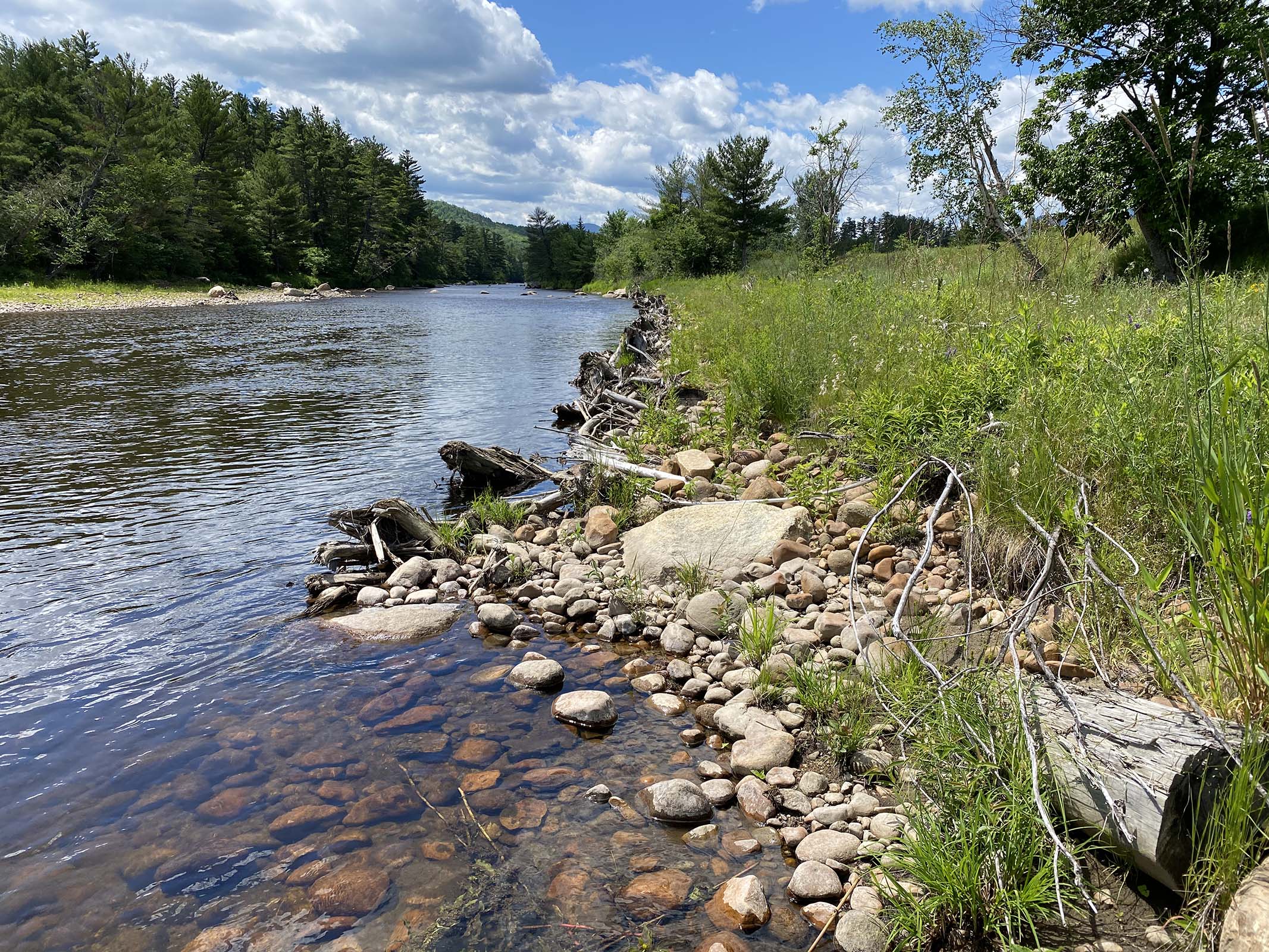
Healthy, stable sections of the East Branch, like this section of the river in the Town of Jay, serve as guides for our restoration designs. We strive to recreate what works on natural, functioning rivers to bring stability to areas that are out of balance.
Six of the 13 projects (see the design maps for the six here) have been elevated to the conceptual design phase and GOSR funds will cover implementation of one to two of the prioritized projects. Learn more about our collaborative approach to resilience planning in the Ausable Watershed by clicking here.
Read the team's final report at this Dropbox link.
A summary of the plan can be found in the sidebar.
West Branch Ausable River
Learn more about AFC's work in the West Branch using the links below.