Bathymetry is the measure of the depth of water in oceans, seas, and lakes. Maps of these depths are referred to as bathymetric maps. They are important tools for navigation, fishing, and scientific studies. So how are these maps made?
Early Methods
Bathymetric mapping dates back to the time of the Egyptians. Only in the last 150 years or so has the field began to take off. In the 1840s, American and British explorers began mapping the Atlantic Ocean. The initial methodology was crude but effective: a weighted rope was lowered over the side of a drifting vessel. Once the weight touched bottom the length of the line was measured. Over time, the methodology was improved by using a thin wire, which dramatically increased the accuracy of the soundings. These simple methods led to the discovery of the Mariana Trench in 1875, and the Mid-Atlantic Ridge and Challenger Deep in 1877.
These techniques were also being deployed to study lakes. In 1846, Henry David Thoreau, well-known philosopher and author, made one of the earliest maps of a lake in North America while he was living on Walden Pond. At the same time, the United States Lake Survey began work to map the Great Lakes.
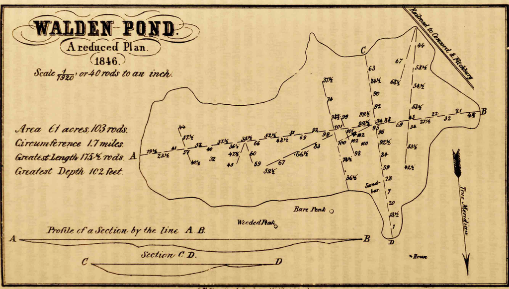
Bathymetric map of Walden Pond created by Henry David Thoreau.
Echo-Sounding
In the early 1900s, efforts were underway to develop systems to allow ships to safely navigate during periods of poor visibility. A system of buoys was deployed that emitted acoustic signals, allowing ships with hydrophones to determine their position. Not long after, a system that could both transmit and receive acoustic signals was developed. This was meant to help ships locate icebergs, which was of great interest after the sinking of the Titanic in 1912. One side benefit of these systems was that they could also detect the ocean floor. By 1922 echo-sounding devices were becoming widely used for bathymetric surveys.
Mapping Small Lakes
Because of their vital shipping routes, the Great Lakes were an obvious priority for bathymetric mapping, but the tens of thousands of small waterbodies across North America also benefit from bathymetric surveys developed over the last 100 years. These lakes and ponds are too small to have employed the large ship-based echo sounding systems being developed in the 1940s. Instead, the line and sinker methodology continued to be used, much in the same way as Thoreau mapped Walden Pond. As technology progressed, smaller echo sounding units, some hand-held, began to be used on smaller waterbodies.
An additional challenge on a small lake or pond is determining the position of a sounding. Mapping was much easier when done from the ice due to the ease of establishing and staying on shore-based transects. It wasn't uncommon for maps to be made with a very limited number of sample points, leaving a lot of room for interpretation when creating detailed bathymetric maps.
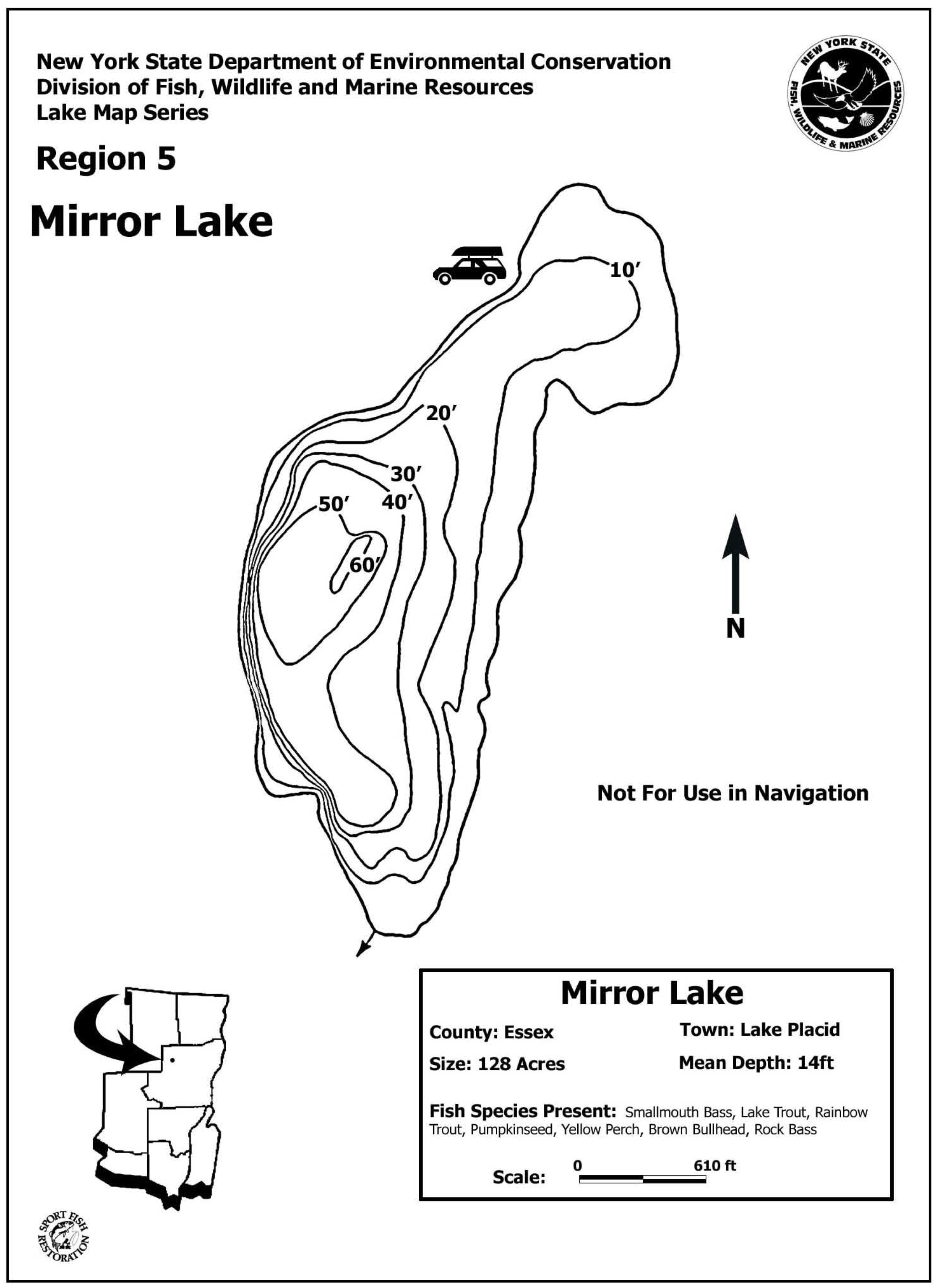
Map of Mirror Lake created by New York State Department of Environmental Conservation. This map was likely created prior to the widespread use of GPS and sonar equipment to map lakes.
Modern Bathymetric Mapping Techniques
Modern techniques for mapping lakes combine the latest in echo sounding and global positioning system technology. These technological advances allow for the collection of thousands of accurate soundings on even the smallest of lakes or ponds. Data processing to create the final map is done in Geographic Information Systems (GIS) software. This allows for not only the creation of the bathymetry of the lake, but also detailed analysis of water volume by depth.
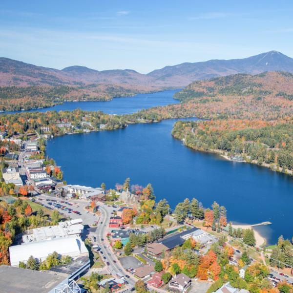
We recently mapped Mirror Lake in Lake Placid, NY and collected over 34,000 soundings on this 126-acre lake. The resulting map revealed bathymetric features not present on an older map (see image above). A second basin was discovered at the south end of the lake, a ridge was identified running through the center of the lake, and much greater detail of the shallow areas of the lake, especially at the north end, were uncovered.
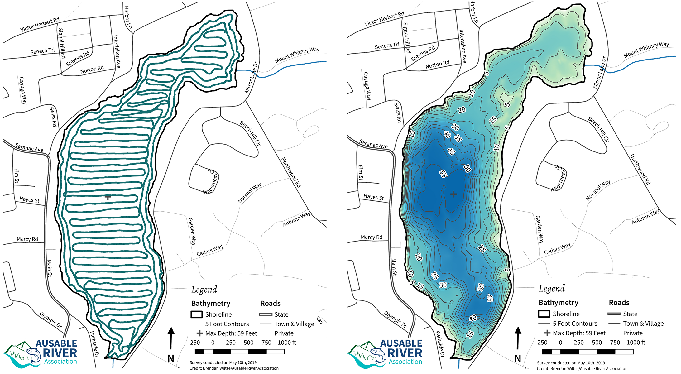
Map of the tracks run to collect bathymetric data on Mirror Lake, over 34,000 data points were recorded (left). Finished map showing the bathymetry of the lake (right).
In addition to measuring lake depth, modern sonar equipment can also distinguish bottom hardness and vegetation biomass. This is important information when studying aquatic plant communities and managing aquatic invasive species. AsRA continually evaluates and adopts modern technology to advance our efforts to protect the clean waters of the Ausable River watershed. The maps we are creating will advance efforts to protect the lakes in the Ausable River watershed, while also providing lake users with a more accurate depiction of the lakes they love.