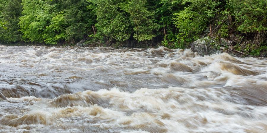
Streamgages are vitally important to understanding the flow of a river and protecting surrounding communities from flooding. The United State Geological Survey (USGS) has over 9,000 streamgages deployed across the country. Many of these feed real-time data to their website, allowing citizens, government officials, emergency management personnel, scientists, and others to monitor the height and volume of water in a river.
How do streamgages work?
Providing real-time data on both the height of a river and the volume of water flowing through it is not an easy task. At the heart of a gage station is a stage recorder. Stage refers to the height of water above a known reference point. The gage station records the river or stream stage on a continuous basis, typically every 15 minutes. These measurements are then sent to a server via either a satellite or cellular connection.
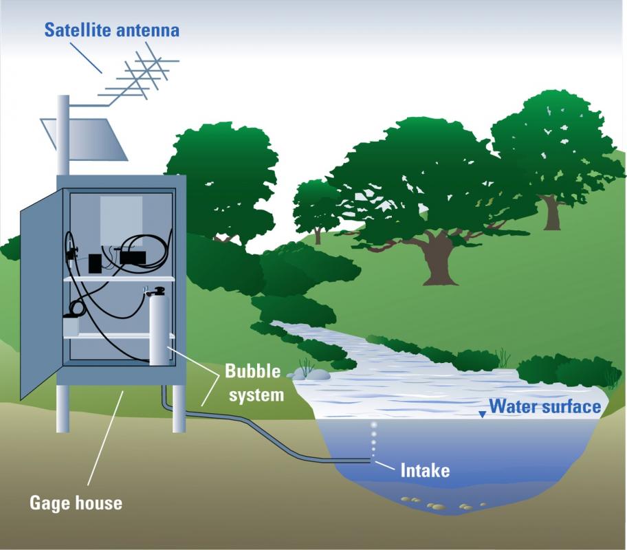
Diagram of streamgage that uses pressured gas to measure the stage of the stream. (Courtesy of USGS)
Gages that report discharge, or the volume of water flowing through the river, do so by converting stage to discharge. There is a very strong mathematical relationship between stage and discharge. The relationship is different for each river or stream, but if it is known for a particular gage station it can be used to convert the continuous stage measurements to discharge. Establishing the relationship requires regularly measuring the discharge of the river or stream across the full range of stage heights experienced at that gage.
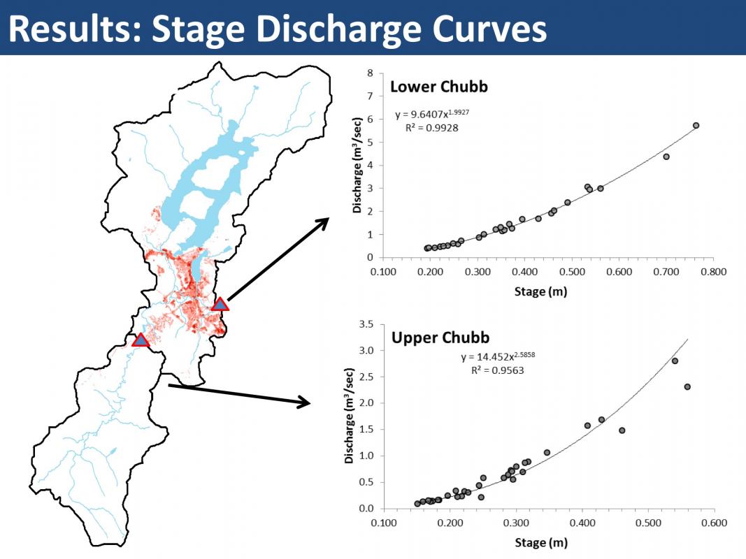
The relationship between stage and discharge for two streamgages maintained by AsRA and AWI on the Chubb River (Laxson et al. 2017).
Discharge in small streams is measured by measuring a cross-section profile of the river, breaking the river into subsections, and measuring the velocity of water in each subsection. The cross-section of each subsection multiplied by the velocity of the water gives the discharge (cubic feet per second) for a given subsection. The discharge for all subsections is summed to calculate the discharge for the entire stream or river. In large rivers, where physically getting into the stream to measure velocity is not possible, acoustic doppler current profilers attached to a small raft are used. They track the movement (velocity) of small particles in the water, while simultaneously mapping the cross-sectional area.
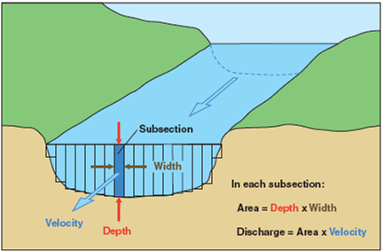
Diagram showing how discharge is measured in a typical stream. (Courtesy of USGS)
Maintaining a Streamgage
Gages require regular maintenance to remain accurate and effective. USGS staff at the New York Water Science Center in Troy, NY regularly visit the two gages on the Ausable River. A typical maintenance visit to a gage involved inspecting equipment, equipment calibration (if necessary), a taking a discharge measurement. Outside of the maintenance of the gage itself, a lot of work goes into maintaining databases, online access, developing and maintaining stage-discharge relationships, and analyzing the data.
USGS provides much of their data online in near real-time, but you'll notice this data is marked as provisional. Not until the data goes through a thorough quality assurance process is the data marked final. In August 2018, the main stem gauge on the Ausable River reported a sudden drop in the river discharge, immediately causing concerns in the local community. It turns out the reported drop was the result of an equipment malfunction, not a change in river discharge. USGS staff replaced the equipment and updated the provisional data.
Ausable River Streamgages
There are two USGS gages in the Ausable River watershed, plus one on the Little Ausable River. Both the main stem gage and East Branch gage have stage-discharge curves established and therefore report both stage and discharge. In addition to these gages, AsRA and the Adirondack Watershed Institute (AWI) maintain two gages on the Chubb River. These gages continuously record data to help us understand changes in river discharge, as well as calculate the total amount of road salt flowing through the river. These two gages do not provide real-time data, but rather log data to internal recorders which is then downloaded on a periodic basis.
Streamgages are costly and time-consuming to construct and maintain, but they provide vital information to our communities. AsRA regularly monitors the USGS gages and is exploring the possibility of installing more gages in the watershed.
Sign-up for our e-newsletter to get weekly updates on the latest stories from the Ausable River Association.
