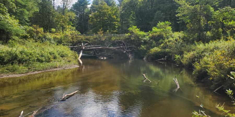
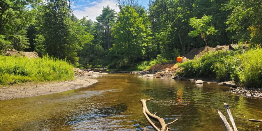
In mid-July 2026, the Ausable Freshwater Center (AFC) finished its in-stream restoration at the Moss Road crossing of the North Branch Boquet River in the Town of Lewis. The pair of undersized culverts that had constricted the river and blocked fish for decades are gone, and a natural channel now carries the river through the site. Over the coming weeks, the Essex County Department of Public Works (DPW) will place a new bridge over the channel. When they do, a longstanding chokepoint for the river will have become an open span, reconnecting roughly 49 miles of river and coldwater tributary habitat upstream.
The old crossing
The Moss Road crossing was a dual-barrel culvert with a combined opening of about 32 feet, forcing a river with a bankfull width of approximately 50 feet through a gap far too small for it. The culvert outlet sat perched above the streambed, creating a drop to the water below that fish couldn't clear at lower flows. A sheet-pile wall above the culvert entrance added a second barrier. Debris often blocked the barrel openings, water pouring from the outlets scoured the channel just downstream, and the flooding resulting from the undersized structure had become a public-safety concern for users of Moss Road.
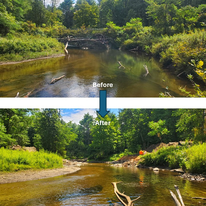
The Moss Road crossing before and after completion of in-stream work, looking downstream. The undersized dual culverts constricted the river and interfered with fish passage; a reconstructed natural channel now runs through the site, ready for the new bridge.
Why this reach matters
This stretch of the North Branch Boquet is exceptional coldwater habitat. Biological surveys regularly find landlocked Atlantic salmon and native brook trout. Opening the barrier puts those upstream miles back within reach of the fish that need them, and it lets the river move sediment through the crossing the way it's supposed to. It's exactly the kind of coldwater habitat our work strives to protect.
What the river was hiding
Before any equipment touched the water, we needed to know what other species lived under the water's surface. A 2024 freshwater mussel survey by Biodrawversity turned up a remarkable number: 5,689 eastern pearlshell in the reach up and downstream of the crossing, with large concentrations right where we planned to work. The eastern pearlshell (Margaritifera margaritifera) is a long-lived, pollution-sensitive freshwater mussel that New York treats as a species of conservation concern, an animal that only persists in clean, cold, well-connected water. In other words, the very mussels complicating our project were themselves proof of exactly the kind of river we were working to protect.
You can't simply work around thousands of rare mussels. So, in coordination with the New York State Department of Environmental Conservation (NYSDEC) and US Fish and Wildlife Service (USFWS), and under a state License to Collect or Possess, Biodrawversity salvaged over 2,400 mussels from the work zone and relocated them by hand to suitable habitat a safe distance upstream, each one re-bedded in its natural position. And when the culverts finally came out in early July, a NYSDEC biologist was on-site to check the streambed beneath them. Seven live mussels found under the northern pipe were carried upstream to join the rest.
Support our river restoration work for clean water and healthy streams. Give with confidence today!

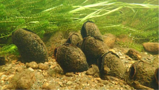
A cluster of eastern pearlshell (Margaritifera margaritifera) in the North Branch Boquet River. A 2024 survey counted thousands in the reach around the crossing, prompting a smaller project footprint and careful hand relocation before construction. Photo by Ethan Nedeau of Biodrawversity.
A smaller footprint, by design
The mussels reshaped the project itself. Our original concept called for extensive bank stabilization and three grade-control structures. To avoid disturbing the mussel bed any more than necessary, we scaled back the in-stream work. Instead, we reconstructed a natural channel through the new crossing with small floodplain benches on each side, protected the toe of the new streambanks with rounded, native boulders, and installed two channel-spanning converging rock clusters to hold the design slope and prevent the river from scouring the bed through the new crossing. The redesign shrank our streambed disturbance to less than 60 linear feet.
None of this was guesswork. Before the design took shape, AFC conducted a geomorphic assessment on over one-half mile of the channel, interpreting dominant geomorphic processes, mapping bed forms and sediment, and carefully measuring bankfull dimensions. We also used a hydraulic model to better understand the stress exerted on the bed and banks during floods and to assess the changes in flooding from removing the bottleneck imposed by the existing undersized culvert. Staff at the USFWS Partners for Fish and Wildlife Program in New York helped refine our design and developed a plan set to guide construction.
That effort mattered because our designs always rely on a solid understanding of the hydrology, hydraulics, and geomorphology of the rivers where we work. Here, the river gathers runoff from about 44 square miles of the surrounding mountains, and upstream of the crossing its valley bottom is filled with fine sands, gravels, and clays left behind by an ancient glacial lake, which drowned these bottomlands at the end of the last Ice Age. That material unravels quickly once a river starts cutting down into it. The two rock clusters installed do quiet but essential work to prevent that tendency: they lock in the channel's elevation, keeping a headcut from marching upstream through those erodible glacial deposits and, just as importantly, keeping the streambed from scouring out beneath the new bridge's foundations.
Building it
The culvert removal and in-stream construction were carried out by JB's Excavation Services, who brings years of stream-restoration experience to the kind of precise work this project demanded. AFC provided daily oversight, and our USFWS partners visited the site during construction to confirm the work matched the design. After the project was completed in mid-July, USFWS gave approval that the in-stream component was built as designed and met its goals of improving fish passage, stabilizing the banks, and restoring natural channel processes.
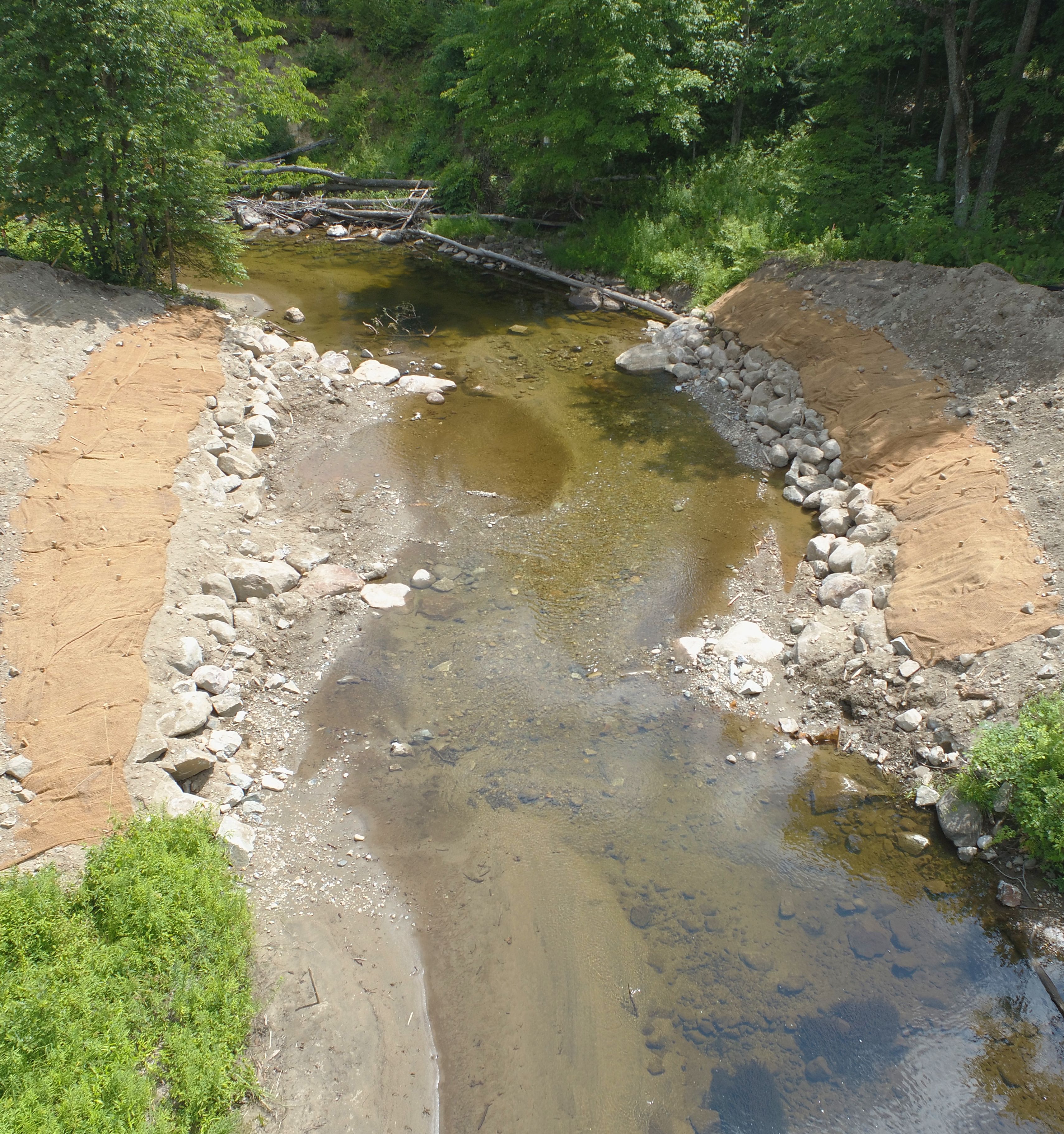
The reconstructed channel and floodplain benches after in-stream work was completed, looking upstream. The freshly placed bench sediments are held in place with a biodegradable coconut-fiber fabric and will be seeded and planted with native vegetation. The areas above the benches are currently under construction by the Essex County Department of Public Works as they prepare the site for placement of a new bridge deck.
What comes next
With the channel complete, the project now passes back to Essex County DPW. Using a bridge design developed by SRA Engineers, they will finish the banks up to the concrete pile caps that carry the deck and launch the new bridge over the coming weeks. AFC will seed and plant the disturbed areas with a native grass-and-wildflower mix and live-staked shrubs and trees, and we'll return to monitor the site under our agreement with USFWS as that vegetation takes hold. The rock clusters and benches were designed to be self-sustaining, with no ongoing maintenance expected.
A partnership worth celebrating
Projects like this one only happen when a lot of people pull in the same direction. Essex County and the Town of Lewis needed a safe, durable road crossing; the river needed its 49 miles back; and the mussels needed us to tread lightly. As it turned out, one carefully designed project could serve all three. That's a model we're glad to share, and a good reminder that the best restoration works with a river's own tendencies, rather than against them.
The river will take it from here. As flow settles into the new channel and salmon and brook trout freely move into upstream habitat, the North Branch Boquet gets to go back to doing what rivers do best — moving water, sediment, and life through the watershed.
Photos by AFC unless otherwise noted. Top photos: Before and after images of the North Branch Boquet River at the Moss Road crossing, looking downstream.
This project has been funded wholly or in part by the United States Environmental Protection Agency under assistance agreement (BIL 4N0A001022-1) to NEIWPCC in partnership with the Lake Champlain Basin Program.
Sign-up for our e-newsletter to get weekly updates on the latest stories from the Ausable River Association.

