The landscape of the Ausable River watershed bears the marks of events that extend far into the Earth's deep past. The rocks, structures, and sediments in the watershed represent distinct occurrences in the natural history of this area. Some of these events occurred over a billion years ago and lasted for hundreds of millions of years. Other events are much more recent and can be seen on much finer time scales. Everything in the natural landscape represents part of that story and owes its present form to one or more of the events that made this place.
The earliest information recorded in the rocks of our watershed and the surrounding area is of a land on the edge of the proto-North American continent (a.k.a. Laurentia). An ocean was closing, and its seafloor was subducted and pulled beneath our continental plate, which led to an eventual collision with another continent, likely proto-South America (a.k.a. Amazonia). When continents collide, their crust thickens to form large mountain ranges, similar to the present-day Himalayas. This collision is thought to be part of the assembly of a supercontinent known as Rodinia where the world's existing continents converged into a single landmass. Eventually, Laurentia and Amazonia rifted and split apart. The closing of the ocean, the ensuing orogeny, or mountain-building event, and eventual rifting lasted for 350 million years from about 1.35 to 1.0 billion years ago. This is known as the Grenville Orogeny.
One of the most common markers we see of this time in our watershed is the iconic anorthosite rock that underlies much of the High Peaks region of the Adirondacks. The anorthosite is a beautiful, crystalline rock with mysterious origins that remain the subject of debate. It has a pale greenish hue when fresh and weathers to a buff or pale gray color over time. Radiometric dating and other field-based evidence tells us that these rocks intruded the crust as a pool of magma, or molten rock, towards the end of one phase of the orogeny at around 1.15 billion years ago.
Another common rock from this period of our past is the Lyon Mountain Granite. This rock hosts the economically important iron deposits, which were tapped by as many as 14 different mines in the vicinity of Black Brook and Au Sable Forks between 1806 and 1906. Again, radiometric and field evidence indicate an intrusion of magma into the crust during the rifting of Laurentia and Amazonia that occurred around 1.04 billion years ago, or about 110 million years after the anorthosite formed The crust in this region experienced many stresses and strains along with intense heat during this age of collision and rifting, which may have initiated some of the major northeast-trending faults and fractures that form the pattern seen in the map below. The rocks also give us another important clue about their origin. Certain minerals can only form under a unique set of temperature and pressure conditions. The minerals in these rocks indicate that they formed at a depth of greater than 25 kilometers (15.5 miles) beneath the Earth's surface.
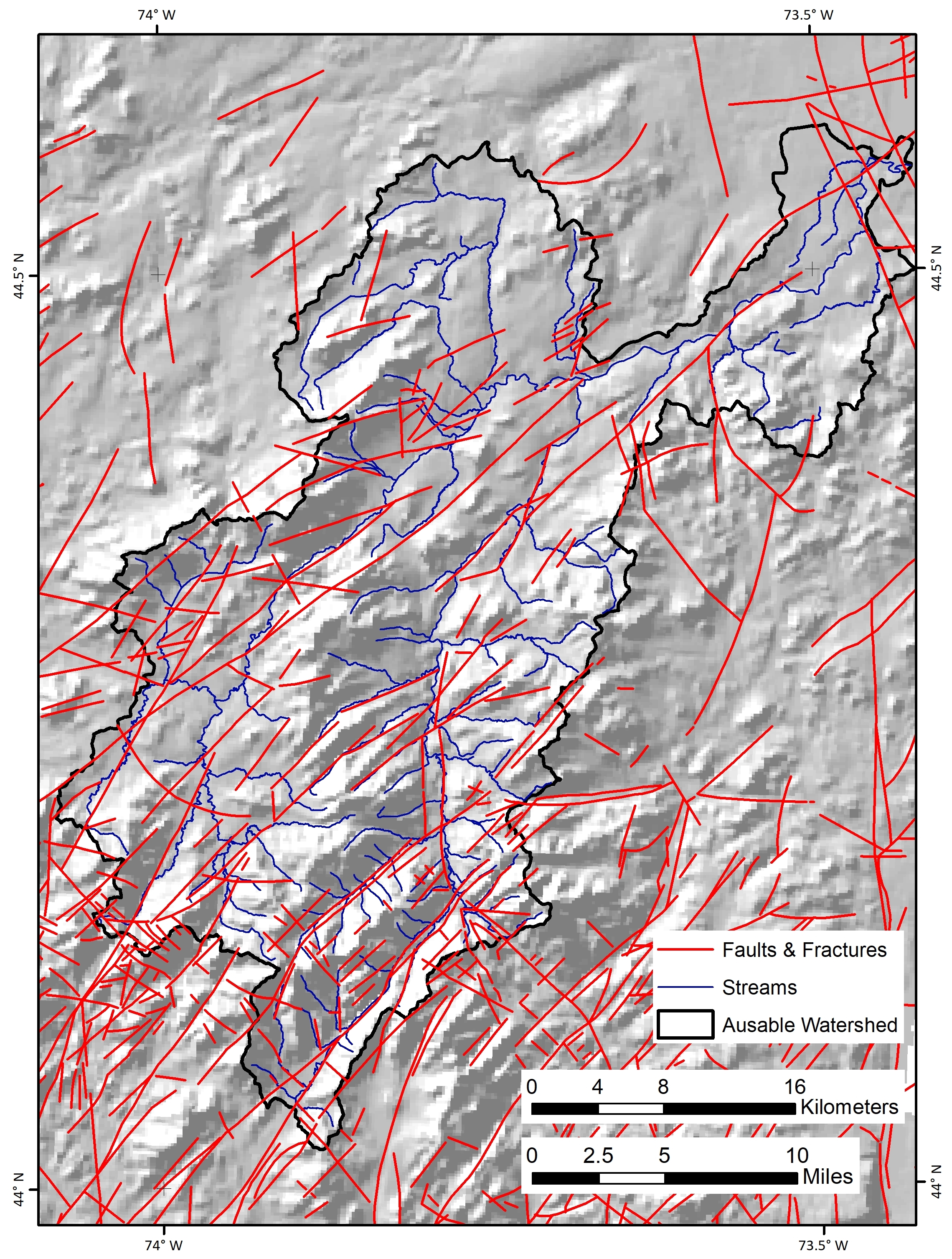
Figure 1. Map of Ausable River watershed with faults and fractures shown in red. Note the dominant north/northeast trend of the larger faults/fractures. Modified from Preliminary Brittle Structures Map of New York: Adirondack sheet (Isachsen and McKendree, 1977).
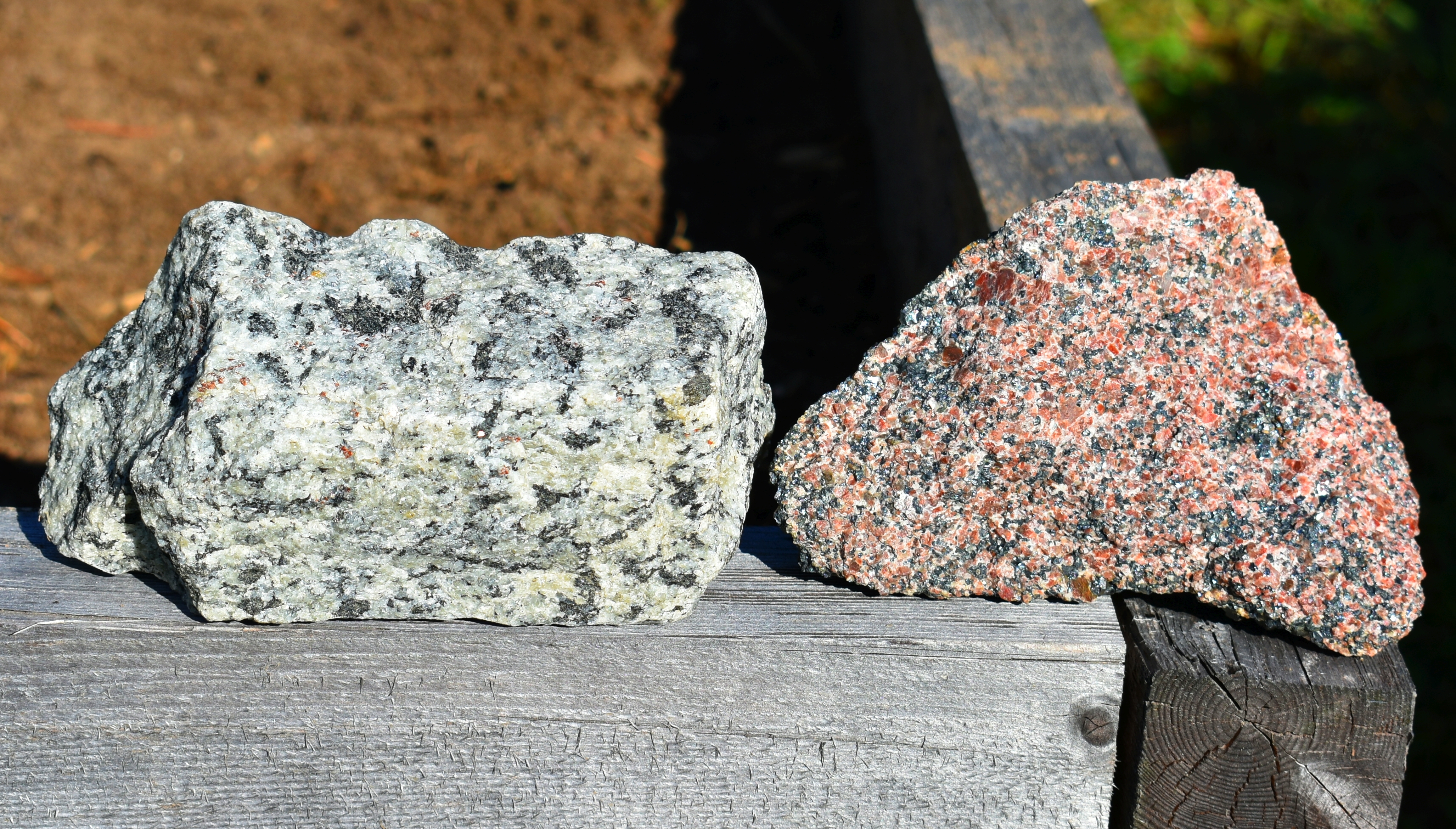
Figure 2. Hand samples of anorthosite (left) and Lyon Mountain Granite (right) from the author's collection. The granite was collected near an abandoned mine in the Town of Black Brook. The dark minerals in the granite are magnetite, which was processed to obtain iron in the 19th and early 20th Centuries.
At this point, a new ocean had opened up before us following the breakup of Rodinia. About half a billion years passed. From about 1 billion years ago until about 540 million years ago, the rocks of the massive mountain range that was built in the Grenville Orogeny were eroded away, exposing ever-deeper rocks from the crustal root. Some of the previously deep rocks in the crust eventually made it to the surface, just as a new period of sediment deposition began. In places throughout the world, sedimentary rocks record a global sea level rise around 540 million years ago, flooding areas that had previously been shedding material and eroding. This marks the beginning of the Cambrian Period. Another iconic rock of Northern New York, the Potsdam Sandstone, records this period of deposition in our region with sediments and forms that are typical of braided streams, beaches, and intertidal zones. In the lower parts of our watershed around Keeseville, these sandstone rocks lie directly on top the crystalline "basement" rocks, like the anorthosite and granite.
Support our river restoration work for clean water and healthy streams. Give with confidence today!

This period of sediment deposition continued for over one hundred million years. Although our watershed has little evidence of it, areas surrounding the Adirondack Dome record deposition of sedimentary rocks like sandstones, limestones, and shales until the land was eventually uplifted and the ocean closed due to the collision of continents forming the supercontinent Pangea. There is evidence that, prior to the uplift of the Adirondacks, these sedimentary rocks likely covered the region to a thickness of at least several kilometers.
After more continental collisions and the subsequent orogenies associated with the formation of the Appalachian Mountains, there is little direct evidence to be found about what was happening in our region. The next event we see in the landscape of our watershed is one that has been going on since the Late Jurassic Period, or around 168 million years ago. The "unroofing" of the Adirondacks has been a slow process, and its origins remain elusive. Evidence from apatite crystals throughout the region indicate uplift has been ongoing since this time, while other evidence shows it may be continuing at a present rate of 2 to 3 millimeters per year. As land is uplifted, it is also subjected to the forces of weathering and erosion. Whatever sedimentary rocks once capped the Adirondack Dome are long gone. Today, the deep roots of the ancient mountains of the Grenville Orogeny sit at the top of our landscape, forming the towering High Peaks of the Adirondack Mountains.
While this slow unroofing process took its time to shed the sedimentary cap and push deep rocks high into the sky, again, there is little direct evidence of anything else that might have been happening here during that time. The next event recorded in our watershed was of a climatic change that buried much of northern North America under a massive ice sheet that was likely 1 to 2 miles thick. While we only see direct evidence of the most recent period of glaciation, evidence from elsewhere indicates that glaciers have come and gone from this area many times over the past 2.5 million years. The most recent episode began in the last 100,000 years, reaching its greatest extent around 28,000 to 24,000 years ago when the ice sheet covered nearly all of New York State. By 15,000 years ago, the ice was melting out of the Ausable River watershed.
The advance and retreat of glaciers had a significant impact on the landscape of the Adirondacks. The characteristic mountain shape of a gently sloping north side with steep cliffs on the southern side indicate that the glaciers were moving north-to-south (see Figure 3). The last glacial advance stripped the area down to bedrock. When it melted away, the landscape was littered with the detritus that was caught up in the ice as the sheet ground its way across the surface. An unsorted pile of sediment consisting of a range of particle sizes from fine silts to large boulders blanketed much of the surface. Gradually, simple life would have returned to the landscape as the movement of water and wind began re-working the sediments left behind by the glacier.
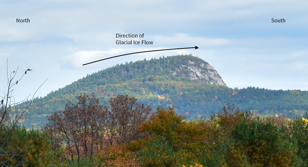
Figure 3. Haystack Mountain in the Town of Jay. The ice sheet moved from left (north) to right (south) in this image. It would have been pushed up the north side of the mountain as it plucked rocks from the southern face, creating the steep cliffs. This type of landform, known as a roche moutonnée, is common in areas that have been glaciated in the past.
Since the valleys of the Ausable watershed drain north/northeast, a relic of the fractures and faults that developed deep in the crust long ago, the melting glacier impounded large lakes that filled the valleys and found outlets through mountain passes into adjacent watersheds like the Hudson or Boquet. We see significant evidence of this time period all throughout the Ausable watershed. Terraces of sandy sediments sit on mountain sides. These terraces were once deltas that formed on the tributary streams draining into a lake that filled the valley of the East Branch Ausable River. Lake shorelines and delta terraces indicate a lake level of 270 meters (885 feet) above the current elevation of the valley floor in the Town of Keene. High-resolution topographic data that has become available over the last several years allows us to see these features in greater detail than ever before.
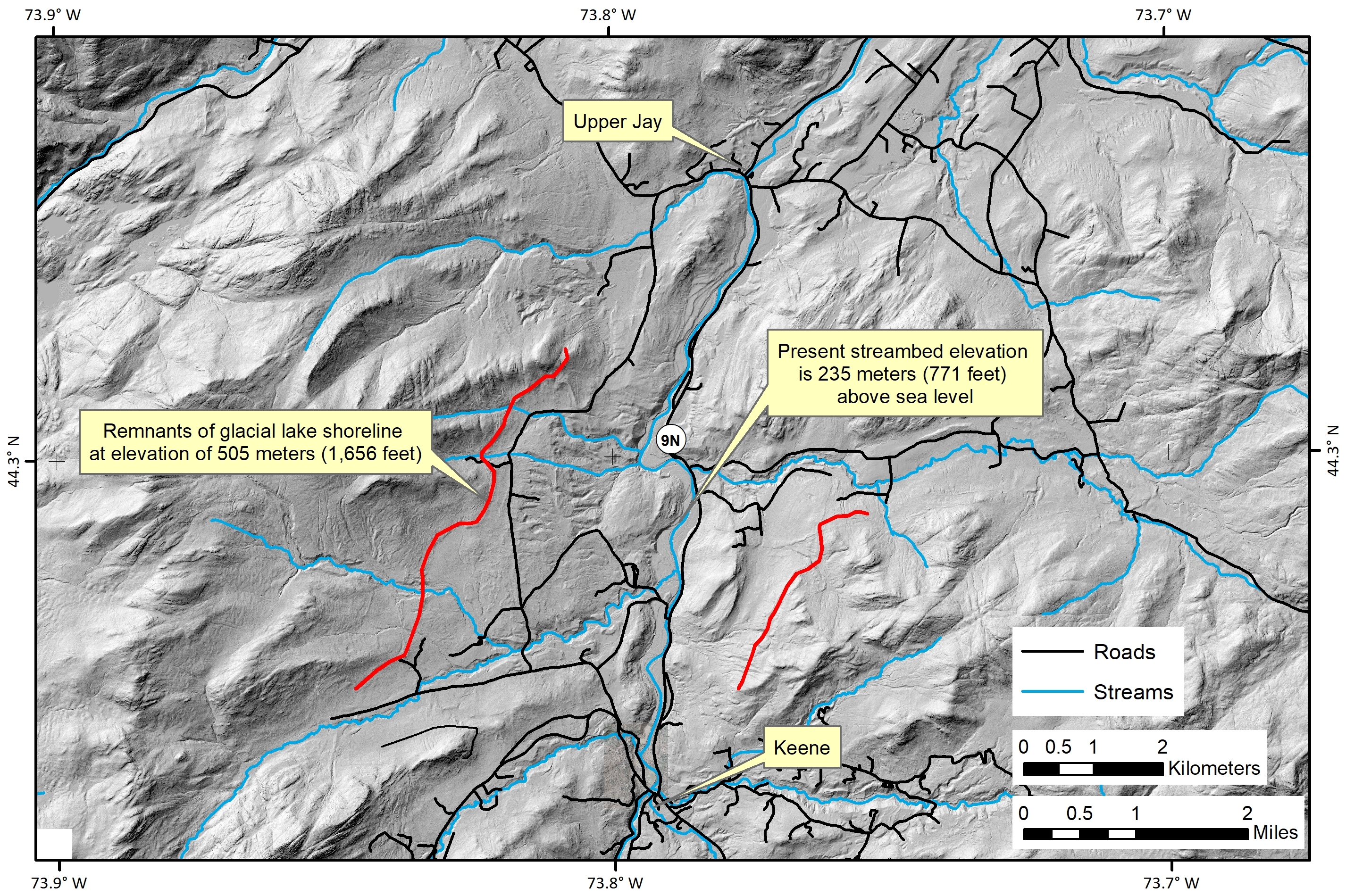
Figure 4. The valley of the East Branch Ausable River between the hamlets of Keene and Upper Jay. Remnants of ancient shorelines (outlined in red) are clearly visible high on the valley walls in high-resolution digital topographic maps. At this point in time, the outlet of this glacial lake was to the south at Chapel Pond Pass, which flowed into a glacial lake that occupied the valley of the Boquet River. The current difference in elevation from the valley floor to the remnant shoreline is approximately 270 meters (885 feet).
It is not only the landforms associated with long-drained glacial lakes, but the sediments that gather in these landforms are a defining characteristic of the watershed today. The well-sorted, sandy outcrops along the roadsides and the sandy soil in your Adirondack garden often reflect the past sorting action of flowing water as it entered a lake and dropped its coarse sediments close to shore while finer material settled out farther offshore.
By 11,000 years ago, the Ausable River valley had mostly drained with the exception of some areas at the lower end of the watershed that were inundated by the Champlain Sea. Throughout this period until the present, water and gravity have been the primary forces shaping the landscape of the watershed. Complex ecosystems became established again and played a major role in landscape development.
While the deep past and the recent past have left their powerful impressions on the watershed, the landscape has undergone a new set of changes that began in the last 200 years, as resource extraction and settlement expanded into the area. Iron mining, timber production, and agriculture transformed the landscape. We also find signs of other recent events in this last period. Forest fires at the turn of the 20th Century, a damaging ice storm in the 1990's, and Tropical Storm Irene in 2011 all left marks that will fade with time but may be transformative to some parts of the watershed.
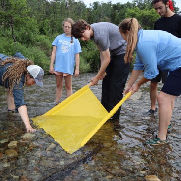
Part of the work in our Healthy Streams program at the Ausable River Association is to address some of these recent human-induced changes in the river and its tributaries. To accommodate logging drives on the river, it was straightened, dredged, and dammed to create the flows needed to move trees downstream. Our infrastructure such as roads, bridges, culverts, and other utilities puts pressure on the river and limits its ability to migrate within its floodplain. By understanding how our landscape developed, we can help guide some of the efforts to restore functions to the river, like geomorphic stability, improved water quality, and biodiverse habitats. The natural landscape of the Ausable River can tell us much about the history of this place. It is a long, complicated history, and knowing our place in that story can help make us better stewards of the watershed in the present time.
Story, maps, and photos by Gary Henry, Stream Restoration Manager. Top photo: Anorthosite bedrock exposure at Jay Falls.
Sign-up for our e-newsletter to get weekly updates on the latest stories from the Ausable River Association.