Building Blocks of Stream Health
Is geomorphology underwater topography? What is the difference between hydrology and hydraulics? And how is all of this related to healthy fish populations? We agree, the terminology of stream health can be a bit overwhelming. But the terms are precise and definable. Understanding them and how they are related is an important step in protecting our waterways.
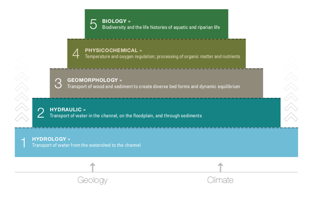
The terms and the concepts behind them are best described using the Stream Function Pyramid Framework developed by Will Harman, Rich Starr, and others in 2012. The pyramid provides a clear but nuanced way to understand the interrelated building blocks of stream health, assessment, and restoration.
The Pyramid Steps
In the diagram above, geology – the soils and bedrock in a watershed – and climate are considered fixed. From the standpoint of flood protection or stream restoration, both are similar decade to decade. Sometimes a major geologic event, such as an earthquake or volcanic eruption, or long-term shifts in climate, changes the baseline, but these events are rare. The steps in our approach to stream health assessment, protection, and restoration follow the pyramid from bottom to top.
Hydrology describes the transport of water from watershed to channel. Understanding its processes helps us describe floods, their frequency and duration. Imagine rain falling in a bowl-shaped watershed – surface water moving through soils, rushing over impermeable surfaces (natural rock or human infrastructure), mixing with groundwater, travelling downslope and creating the channels we see as rills, streams, and rivers. Without surface water flow, there would not be channel formation and no aquatic ecosystem.
Hydraulic processes include the transport of water in a channel, on a floodplain and through sediments. They describe how water behaves in a channel and its interactions with bed, banks, floodplain, and groundwater. Water's capacity to move sediment and other material as it interacts with a channel is the transition to the next step, geomorphology.
Geomorphology is the transport of wood and sediment to build and rebuild diverse bed forms: deep pools, fast riffles, pocket water, steps and falls, plus floodplain structure and near-stream plant diversity. Geomorphic measures describe the size, density, mobility, and type of material needed to form and reform channel and floodplain, and the subtle migration of banks, especially around bends where, in healthy systems, erosion is always taking place. Together with hydrology and hydraulics, geomorphic processes, in a minimally disturbed watershed, create a dynamically stable stream system appropriate to the underlying geology and climate of a region and set the stage for clean water and biodiversity.
Physicochemical functions include temperature and oxygen regulation and the processing of organic matter and nutrients. These features of water quality are highly dependent on each of the processes below. Chemicals and fertilizers can move into a channel as water flows across a watershed, banks eroding because of hydraulic forces can effect water clarity, and oxgenation of water depends on geomorphic bed diversity. Fast riffles, deep pools, and a dense riparian buffer are key to regulating water temperatures. Monitoring water quality and temperture provides an early warning system for changes in the supporting processes.
Biology is at the top of the pyramid because aquatic life – instream animals, such as fish and macroinvertebrates, as well as plants and near-stream animals, such as frogs and salamanders – depends on all the underlying functions. A healthy aquatic ecosystem must have sufficient water contributed from the watershed, the right levels of hydraulic forces, proper bed form diversity and channel stability, suitable temperature and oxygen regimes, and so on. Noting changes in the presence, absence, population structure, and abundance of key species, such as stoneflies, spring salamanders, and brook trout, helps us keep track of changes in the levels beneath.
When we restore an impaired section of a stream, such as the Dream Mile on the West Branch Ausable River, we rebuild diverse bed forms: deep pools at bends, steep glides, shallow, rapid riffles, and flat runs with pocket water and boulders interspersed. To do this, we use natural materials that direct flows to reinforce the channel form and function and restore the geomorphic processes. First, we study the hydrology and hydraulics of the system – how often flood flows came to the bankfull stage, how connected the channel bed is to its floodplain. And we know the potential of this section of stream because we have measured, modeled, and monitored intact functioning sections elsewhere on the West Branch.
The success of the Dream Mile restoration effort thus far has been evident in the stream's ability to manage slabs of winter ice, high and low flood flows, and to recreate its form – amply managing the hydrologic and hydraulic processes inherent in its watershed. Improvements in water quality take years, but a lush riparian base is established, and trees and shrubs are beginning to take root. Most notably, our work provides immediate habitat for macroinvertebrates, fish, birds, frogs, beaver, and much more. The pyramid provides a complex yet clear path toward understanding stream health and helps us restore it when it is compromised.
Sign-up for our e-newsletter to get weekly updates on the latest stories from the Ausable River Association.
