Over the past year, my work in the Ausable and Boquet watersheds has allowed me to gain intimacy with the rivers and streams that drain water from our landscape. My geomorphic surveys provide the opportunity to begin unravelling the mathematical relationships between the sizes and shapes of the channels and the area of land being drained. The larger the drainage area, the more water that needs to be moved, which means that the size of the channel will typically increase with drainage area. This is a fairly straightforward concept that most people easily grasp. The Ausable River in Keeseville has a larger channel than the East Branch Ausable River in Keene because it drains more area. The question I have been probing over the past year is, what are the mathematical relationships between drainage area and channel dimensions?
The dimensions of a channel are largely controlled by what fluvial geomorphologists refer to as bankfull discharge. This is a discharge, or flow, that fills the entire channel and occurs on average about once every 1 to 2 years in our region. Over time, this particular discharge moves more sediment and, therefore, exerts more control over the size and shape of the channel than other larger, but less frequent floods (e.g., 10-year flood, 50-year flood, etc.). The bankfull discharge often leaves indicators that can be found through careful observation and measurement as part of a geomorphic survey. Discussing the process of measuring and analyzing the bankfull characteristics of the streams in our region is beyond the scope of this piece, but we can note that these characteristics have been studied on a regional basis for several decades. These relationships are best understood across regions with similar geological and climatic conditions (i.e., hydrophysiographic regions). It would be useless to compare the bankfull characteristics of Adirondack streams with streams in the high desert plains of the Western U.S. The geology and climates are too different. However, if we examine these relationships within the same hydrophysiographic region, patterns begin to take shape.
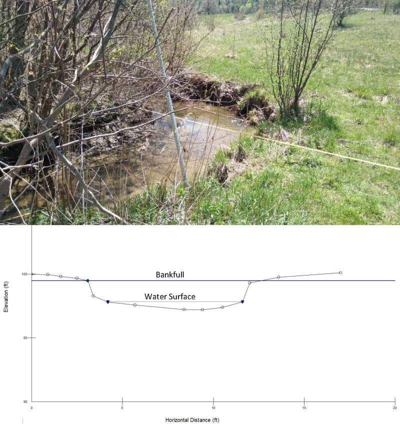
Top Image: Photo of a cross section location measured during a recent geomorphic survey. A tape is stretched across the channel where the cross section is to be measured. The stadia rod in the foreground is used to track the changes in elevation as you move from the beginning to the end of the tape. Bottom Image: Diagram of the cross section measurements showing the channel dimensions. There are several different types of bankfull indicators that may be observed in the field. Here, bankfull is identified by the abrupt break in slope at the transition of the channel to the floodplain.
Support our river restoration work for clean water and healthy streams. Give with confidence today!

If there is a relationship between the bankfull channel characteristics and drainage area, then what is the use of unraveling this mystery? Sure, science geeks might simply enjoy the challenge of piecing this puzzle together, but what are the applications? Understanding these relationships is most useful when applied to our work in stream restoration and culvert replacement. In areas where communities and infrastructure limit the ability of rivers and streams to self-repair, it can be difficult to determine the appropriate dimensions to use in the restoration of channels or the replacement of undersized culverts. Bankfull indicators may be absent from these areas, and restoration professionals need guidance on how to restore geomorphic function, which supports higher stream functions like water quality and diverse biological communities. Knowledge of stable channel dimensions is a critical first step in the self-sustaining restoration practices that are used by AsRA and our partners at the U.S. Fish and Wildlife Service.
Over the past year since June 2021, I have collected detailed geomorphological survey data on over 6,800 feet (1.3 miles) of streams in the Ausable and Boquet watersheds. As more data are gathered, relationships are starting to take shape that show how drainage area affects the bankfull dimensions of channels in our region. While this work has been undertaken as part of our efforts to design and replace climate-ready culverts in the watersheds, the Lake Champlain Basin Program (LCBP) awarded a grant to AsRA in 2022 to identify and survey reference-quality streams to further our understanding of these bankfull relationships. As their name suggests, reference-quality streams are streams that are geomorphically stable and can serve as a reference for understanding bankfull relationships within a hydrophysiographic region.
As I continue to gather more data over the coming year, I look forward to updating this story with the findings of my analyses of reference-quality streams. The support that AsRA receives from LCBP, USFWS, and our dedicated private donors for our restoration work is vital to our continuing search for solutions. Rigorous field science has always been the backbone of our mission of helping communities protect our streams and lakes. This effort will be another opportunity to further that mission and strengthen the scientific foundation of our work to protect and restore healthy streams in the Ausable River watershed.
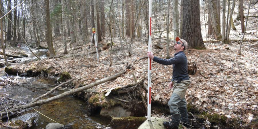
Story and diagrams by Gary Henry, Stream Restoration Manager. Top photo by Liz Metzger: Gary measuring a benchmark as part of a survey on a tributary to the West Branch Ausable River.
Sign-up for our e-newsletter to get weekly updates on the latest stories from the Ausable River Association.