Private landowners living near or owning property along a river or stream in the Ausable and neighboring watersheds often reach out to us about eroding banks, flooding, and other streamside concerns. These inquiries inspired us to provide some general background information about the process we follow in our ongoing efforts to assess and restore streams that often suffer from the combined effects of historical land use (e.g., clear cut logging in the 19th and 20th centuries, encroachment by public and private roadways, private dam failures, etc.) and the increase in extreme storms due to our changing climate. The short answer is that there are no quick and easy fixes. The process takes time and can be expensive, depending on the extent of the degradation and the size of the river or stream. Knowing this at the outset can help landowners understand that, although there are options available to address these common problems, restoring the self-sustaining function of a stream is complicated.
Problem Identification and Assessment
When they've identified a problem area in a stream on their property, many landowners reach out to us after seeing our work in other areas of the watershed. However, they are often unaware that these restoration efforts are typically part of a much larger process to identify, prioritize, and find funding to implement projects that often spans several years. When we start moving forward on a project, the first step is a detailed assessment of the existing conditions so that we can effectively address the causes of dysfunction and restore balance in the system. It would be pointless to simply fix an eroding bank, for example, if the cause of the problem lies somewhere upstream. That's why it is critical to understand the hydrology, hydraulics, and geomorphology of the surrounding system, and that's what we seek to learn in our assessments.
A full geomorphic survey to assess the conditions of the stream can vary in time and costs based on the size of the problem. Some areas require us to assess several hundred to several thousand feet of channel, utilizing costly surveying equipment that requires specialized knowledge to use and process the data that are collected. A survey may take several days or weeks. We may need access to areas upstream and/or downstream of the landowner's property, engaging other landowners for permission to pass through their property. At a minimum, these surveys typically cost several thousand dollars, including field work, data processing, and equipment maintenance by multiple scientific staff. There are many different characteristics that we capture in the survey process. An accurate dataset is the foundation of all the work that follows in this process, and it takes years of training and professional practice to collect and interpret these data correctly.
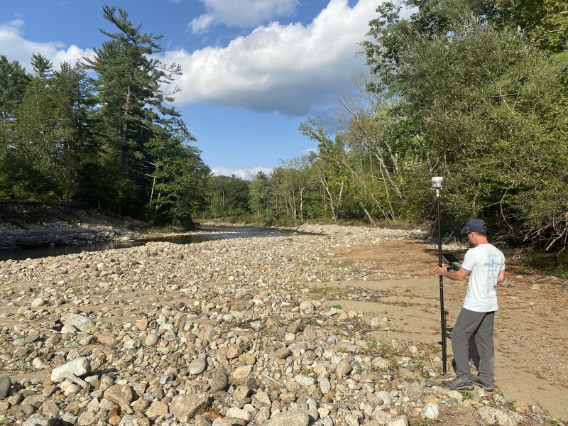
A geomorphic survey is the foundation of the design work on our restoration projects. These data must be collected and interpreted by trained professionals with an understanding of stream forms and processes.
If we find that the problem is localized and can be addressed with a few minor tweaks in the stream channel, then the initial survey, processing, and analyses might be all we need to develop a restoration plan. If it's a bigger problem, we might need to do additional analyses on watershed hydrology and channel hydraulics to better understand the forces that are driving the system out of balance. We may be able to do some of this work in-house, or we may need to engage the services of a professional engineer for more complex model development. Additional work translates into additional costs to move the project forward.
Project Design and Permitting
Once we understand the problem through detailed survey and assessment, we can begin to develop a design, usually with our partners at the U.S. Fish and Wildlife Service. The costs associated with a design cover staff time spent evaluating different design alternatives and seeking input from the agencies that, in addition to USFWS, will ultimately need to sign off on the permits required for any instream work (e.g., NYS Department of Environmental Conservation, Adirondack Park Agency, etc.). For a simple project, these costs will be minimal since we've covered most of the bases in our initial assessment. For larger projects that involve complex modeling of proposed design options, the costs can be much more substantial. We have experience working under both types of scenarios. When the design process is complete, we work with the relevant state and federal agencies for approval to implement the project. Permitting small projects can be relatively straightforward, but more complex projects might require significant staff time to brief agencies and prepare the documentation necessary to obtain permits that allow us to bring machinery and materials into the stream channel for the construction of design elements such as rock vanes and toe wood benches.
Support our river restoration work for clean water and healthy streams. Give with confidence today!

Funding the Project
We are a nonprofit organization with a small but dedicated staff of professional scientists that works with local towns and landowners to help inform responsible stewardship, assess the health and function of watersheds in the region, and, where appropriate, implement projects to restore habitat and provide flood resilience for our communities. The funding for this work often comes from federal, state, and local agencies and governments. In a few cases, the landowner has been able to fund the work we undertake. Unfortunately, we do not have an extra budget to implement restoration projects on private property when a landowner has concerns about problems in a stream that flows through their property. Most of our projects involve a much larger planning process that goes beyond a single landowner's property. We assess entire stream systems to inform where restoration efforts can have the highest public benefit. We then leverage the planning process to help secure funding from the different agencies and funders based on their priorities and available resources.
The cost of these projects can be quite significant. They often exceed six figures, even for small stabilization efforts. Larger projects will approach or exceed seven figures for implementation. In fact, most of our projects require funding from multiple sources due to the high costs of construction, especially considering the rising costs associated with equipment, labor, and materials.
Implementing the Project
After conducting a detailed assessment, evaluating a range of design alternatives, obtaining the necessary permits, and securing funds for construction, we can identify a contractor with expertise in stream restoration. In our region, there are only a few contractors with the equipment and experience to perform this type of instream construction. We work with the contractor to find appropriate materials for construction – native, round boulders of suitable sizes and native, locally sourced trees with intact root wads for toe wood benches. Staging of materials and access to the site is coordinated with landowners to ensure that equipment can move in and out of the channel on a daily basis and that the process moves smoothly once it begins. Instream construction requires daily oversight from our staff to ensure compliance with the state and federal permits. Construction may range from days to weeks, depending on the size of the project.
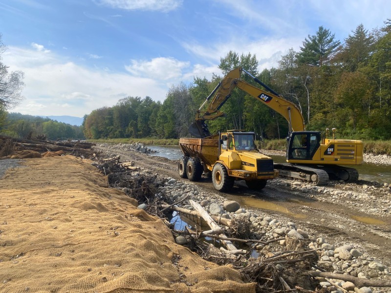
Implementing a stream restoration project requires significant planning and coordination. During construction, AsRA staff provides daily oversight to ensure that the project meets the design specifications and complies with the standards required by the permitting agencies.
Options for Landowners
For many landowners, the cost of funding a comprehensive restoration effort from assessment through construction is simply too high. That doesn't mean that nothing can be done. As with any problem, prevention is the most cost-effective option when it comes to taking care of rivers and streams. Maintaining a healthy, wide buffer of streamside vegetation (50 feet or more) can be incredibly effective in preventing the types of problems that lead to bank erosion and loss of aquatic habitat. With funding from the Lake Champlain Basin Program, we are able to offer assessments of riparian health with recommendations on how to improve or maintain these buffers. In many cases, bank erosion may have progressed beyond the point where planting can reduce or repair the damage and reverse the process. Our staff has expertise in identifying these scenarios and can offer advice on what options are available to landowners.
It's important for us to hear from landowners who are concerned about degraded streams in the watersheds where we work. Our work depends on having a bird's eye view of the processes and problems that threaten stream health in these watersheds and intimate knowledge on the ground. We are always seeking solutions to manage and mitigate the common issues that many local streamside landowners face, but we also need to manage expectations about what is feasible when many of these problems are so widespread. To be most effective, stream restoration requires a solid foundation of assessment and design work to ensure that the proposed solutions can withstand the forces that caused these channels to degrade in the first place. Complicated problems require thoughtful solutions, and we are here to help landowners think through the best approaches to bring dysfunctional streams back into balance.
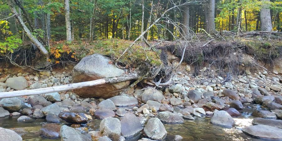
Story by Gary Henry, Stream Restoration Manager. Top photo: An eroding bank with toppling trees along the East Branch Ausable River.
Sign-up for our e-newsletter to get weekly updates on the latest stories from the Ausable River Association.
